When most people hear the word desert, they picture endless dunes, blazing sunshine and almost no vegetation. But a desert is defined mainly by how little precipitation it receives, not by heat or sand. That is why the two largest deserts on Earth are frozen landscapes rather than hot, sandy ones.
The ranking below uses approximate surface area, and it includes both polar and non-polar deserts. Desert boundaries can vary slightly between geographic sources, especially where one dry region gradually merges into another, so the figures should be read as widely used estimates rather than exact surveyed borders.
So, let’s check out the Top 10 Largest Deserts in the World and see how these enormous dry regions stretch across continents, climates and some of the most extreme environments on Earth.
1. Antarctic Desert – About 14.2 Million km²
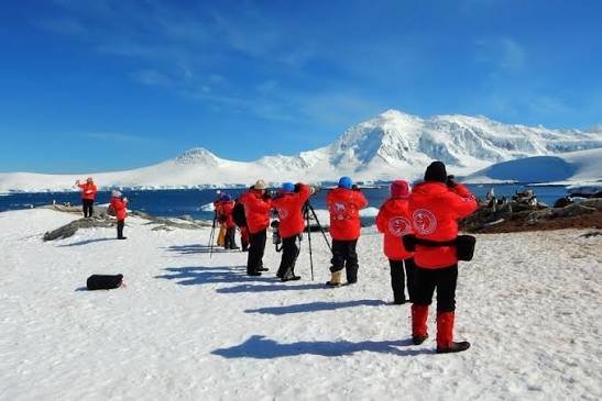
The Antarctic Desert is the largest desert in the world, covering almost the entire continent of Antarctica. Its area is roughly 14.2 million square kilometres, or about 5.5 million square miles.
It may seem strange to call a continent covered in ice a desert, but Antarctica receives extremely little precipitation. Much of the interior gets the equivalent of only a few centimetres of water each year, mostly as snow. The air is exceptionally cold and dry, so very little moisture is available.
Antarctica is also the coldest place on Earth. Huge ice sheets dominate the continent, while areas such as the McMurdo Dry Valleys are so dry and barren that scientists often compare them with conditions on Mars. Its enormous size makes the Antarctic polar desert larger than every hot desert on the planet.
2. Arctic Desert – About 14 Million km²
The Arctic Desert is the second-largest desert in the world, with a generalized area of about 14 million square kilometres. It extends across the far north around the Arctic Ocean and includes parts of Greenland, Canada, Alaska, Russia and several northern European regions.
Like Antarctica, the Arctic qualifies as a desert because precipitation is very low. Snow may remain on the ground for long periods, but annual snowfall is often limited because cold air holds very little moisture.
The landscape is far more varied than the Antarctic interior. Sea ice, tundra, glaciers, rocky islands and permanently frozen ground all occur across the wider Arctic region. Despite its severe climate, it supports animals such as polar bears, Arctic foxes, seals and reindeer in areas where food is available.
3. Sahara Desert – About 9.1 Million km²
The Sahara is the world’s largest hot desert and the third-largest desert overall. It spreads across roughly 9.1 million square kilometres of North Africa, covering an area almost comparable with the size of the United States.
The Sahara extends through or into countries including Algeria, Chad, Egypt, Libya, Mali, Mauritania, Morocco, Niger, Sudan and Tunisia. Although giant dunes are its most famous image, much of the desert is actually made up of rocky plateaus, gravel plains, mountains and dry valleys.
Temperatures can become extreme during the day, while nights may be surprisingly cold. Rainfall is scarce and irregular, yet the Sahara still supports specialised plants, animals and human communities around oases, mountains and desert margins. Its enormous scale has shaped trade, migration and culture across Africa for thousands of years.
4. Arabian Desert – About 2.6 Million km²
The Arabian Desert covers most of the Arabian Peninsula and has an approximate area of 2.6 million square kilometres. It stretches across Saudi Arabia and into countries including Yemen, Oman, the United Arab Emirates, Jordan and Iraq.
One of its most famous regions is the Rub’ al Khali, or Empty Quarter, one of the largest continuous sand deserts on Earth. Vast dune fields rise across the landscape, while other parts of the Arabian Desert contain gravel plains, rocky plateaus and salt flats.
Summer temperatures can be severe, and rainfall is extremely limited. Despite these conditions, the region has supported Bedouin communities for centuries and today contains some of the world’s most important oil and natural-gas reserves. Modern cities now sit at the edges of landscapes that remain among the driest and harshest on Earth.
5. Gobi Desert – About 1.3 Million km²
The Gobi Desert stretches across southern Mongolia and northern China and covers roughly 1.3 million square kilometres. It is one of the world’s great cold-winter deserts.
Unlike the classic image of a desert, much of the Gobi is not covered by high sand dunes. Large areas consist of exposed rock, gravel plains and dry steppe. Winters can be bitterly cold, with temperatures dropping far below freezing, while summers may become very hot.
The Gobi has enormous historical importance because routes connected with the Silk Road passed through its wider region. It is also famous for major fossil discoveries, including dinosaur eggs and skeletons found during 20th-century expeditions. Its combination of extreme temperature changes and sparse rainfall creates one of Asia’s toughest environments.
6. Patagonian Desert – About 673,000 km²
The Patagonian Desert, also called the Patagonian Steppe, occupies a huge area of southern Argentina and extends toward the Andes. At roughly 673,000 square kilometres, it is the largest desert in Argentina and one of the biggest cold deserts outside the polar regions.
Its dryness is strongly linked to the Andes Mountains. Moist air arriving from the Pacific loses much of its precipitation on the western slopes, leaving areas to the east in a rain shadow.
The landscape is dominated by windswept plateaus, gravel plains, scrub and open steppe rather than endless sand. Strong winds are common, and winters can be cold. Animals such as guanacos, rheas and Patagonian foxes have adapted to the sparse vegetation and exposed terrain.
7. Great Victoria Desert – About 648,000 km²
The Great Victoria Desert is Australia’s largest individual desert, covering about 648,000 square kilometres across Western Australia and South Australia.
Its landscape includes sand dunes, stony plains, salt lakes and areas of low scrub. Rainfall is limited and unpredictable, but the region is not completely lifeless. Spinifex grasses, salt-tolerant plants, reptiles and desert-adapted mammals survive across the vast interior.
The Great Victoria Desert is also culturally important to Aboriginal Australian communities whose connection with the land stretches back thousands of years. Much of the desert remains sparsely populated, and its remoteness helps preserve large areas of relatively undisturbed arid habitat.
8. Kalahari Desert – About 570,000 km²
The Kalahari Desert covers a vast part of southern Africa, particularly Botswana, Namibia and South Africa. Using a more narrowly defined desert boundary, its area is about 570,000 square kilometres, although broader definitions of the Kalahari basin can produce much larger figures.
The Kalahari receives more rainfall than many true deserts, so parts of it support grasses, shrubs and scattered trees. For this reason, it is sometimes described as a semi-desert rather than an extremely arid desert.
Its red sands are among its most recognisable features. Wildlife is surprisingly rich and includes lions, cheetahs, meerkats, antelope and many bird species. The San people have lived in the wider Kalahari region for generations and developed deep knowledge of surviving in its dry environment.
9. Great Basin Desert – About 492,000 km²
The Great Basin Desert is the largest desert in the United States, covering roughly 492,000 square kilometres across much of Nevada and parts of Utah, Oregon, Idaho and California.
It is a cold-winter desert created largely by the rain-shadow effect of mountain ranges to the west. Moist Pacific air loses precipitation before reaching the interior, leaving the Great Basin much drier.
Unlike the cactus-dominated deserts farther south, the Great Basin is strongly associated with sagebrush and other plants adapted to cold winters. Mountain ranges rise between broad dry valleys, creating a distinctive basin-and-range landscape. Snow can fall during winter, showing once again that deserts are defined by dryness rather than heat.
10. Syrian Desert – About 492,000 km²
The Syrian Desert occupies a broad dry region of the Middle East across parts of Syria, Jordan, Iraq and northern Saudi Arabia. Its generalized area is roughly 492,000 square kilometres, placing it close to the Great Basin Desert in size.
The landscape is mostly rocky and gravelly rather than dominated by giant dunes. Rainfall is scarce, vegetation is thin, and temperatures vary sharply between seasons and between day and night.
Despite its harsh environment, the Syrian Desert has long been crossed by trade and migration routes linking the Mediterranean, Mesopotamia and the Arabian Peninsula. Historic settlements and caravan centres developed around water sources, showing how even very dry landscapes have played an important role in human history.
Why Are Polar Regions Classified as Deserts?
A desert is defined mainly by low precipitation, commonly less than about 250 millimetres a year, rather than by temperature. This is why Antarctica and large parts of the Arctic qualify even though they are covered with snow and ice.
Cold air cannot hold as much moisture as warm air, so polar regions can receive very little new snow during a year. The ice visible today may have accumulated over thousands of years rather than representing heavy annual precipitation.
If polar deserts are excluded, the Sahara becomes the largest desert in the world. It is therefore more accurate to call the Sahara the world’s largest hot desert rather than simply the world’s largest desert.
Final Word
The world’s largest deserts show that dryness can create very different landscapes. Antarctica and the Arctic are frozen polar deserts, the Sahara and Arabian Desert are dominated by extreme heat and aridity, while the Gobi, Patagonia and Great Basin experience cold winters as well as dry conditions.
Together, these enormous regions demonstrate that a desert is much more than a sea of sand. It can contain ice sheets, mountains, rocky plains, grasslands, salt flats and ancient human routes – all connected by one defining feature: very little precipitation.